


Name: Soulard Market
Address: 730 Carroll Street
Architectural Firm/Architect: Albert Osburg (for City
Designation: City Landmark
History:
Originally, the 64-acre tract extending westward from the Mississippi River to Broadway and from Park Avenue to Lesperance Street was given to Gabriel Cerre as a Spanish land grant in 1780. He developed it into one of the first fruit orchards around St. Louis and later conveyed it to Antoine Soulard, who married Cerre´s daughter, Julie, in 1795. Later, additional lands to the west of the original holding were granted to Soulard for his services as surveyor by Governor Carlos Delassus. This included the present site of the market, which is said to have been used as such since 1779.
After Soulard´s death in 1825, his widow fought a lengthy legal battle over the land. This was decided in her favor in 1838, at which time she donated the market site to the City. The first market buildings were built there in the 1840s and were enlarged by the addition of a market hall in 1865. The City purchased these buildings in 1867 and they were in use until they were destroyed by the 1896 tornado.
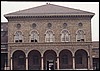
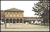
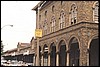
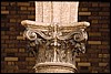
New market sheds were erected and, in 1929, the present market complex was completed. It consists of two flanking market stall structures with a two-story central building. Its second floor contains an auditorium and stage affording a meeting place for neighborhood activities. This building is said to have been inspired in its design by the Italian Renaissance Foundling Hospital at Florence by Filipo Brunelleschi (1377-1446).
People
Cerre, Gabriel
Delassus, Carlos
Osburg, Albert
Soulard, Julia
Soulard, Antoine
 |
 |
 |
 |
 |
 |
 |
 |

people
• structures • events
• sources • home
about
historic preservation• new entries• 4 kids only• map it!
This
site was made possible by: the City of St. Louis Planning and Urban Design Agency and
the City of St. Louis Community
Information Network.
This site was funded in part by Federal funds administered by the Missouri State Historical Preservation
Office, Missouri Department of Natural Resources, The National Park Service, and the U.S. Department of the Interior.
Version 1.0